Updated January 7, 2025
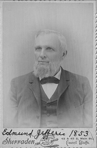
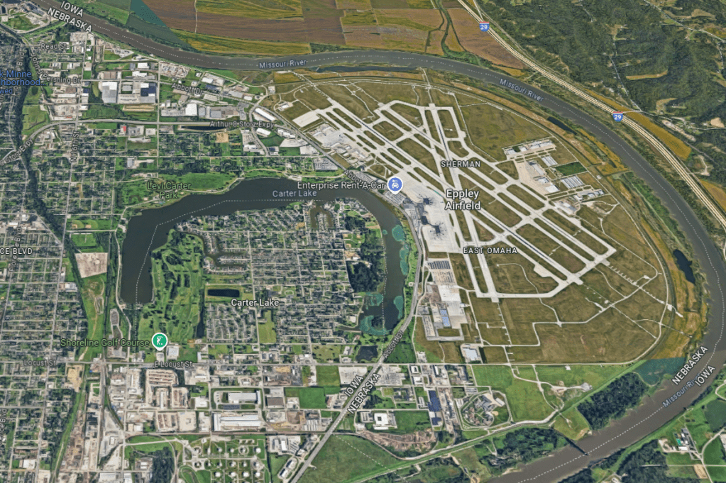
Located along the Missouri River just north and east of downtown Omaha is Eppley Airfield. Decades before it was constructed, the land consisted mostly of small farms. It started with Edmund Jefferis who moved to Council Bluffs from Delaware with his brother Thomas. After the Nebraska Territory was established in 1854, Edmund received the title to the 30 acres of land he claimed in the area of East Omaha. According to North Omaha History, Edmund, a farmer by trade, eventually acquired more than 2,000 acres of land.
This portion of rural Nebraska was unlike anything else in Omaha City. On its eastern edge was the Missouri River which often flooded the area. On its western edge were the bluffs that ran along the Kountze Place, Miller Park and Minne Lusa neighborhoods.
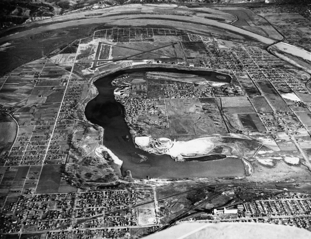
The area remained as an undeveloped farming community for decades until 1877. Even before that, the Missouri River had a tendency to slightly alter its course and follow a new or different channel. For the most part this was gradual but in 1877 an ice jam formed at an area along the river called the Saratoga Bend. This resulted in the river shifting course about a mile southeast. I haven’t been able to confirm whether this was caused by a flood or just high water. Regardless though, when the water retreated, it left a crescent shaped body of water. The land inside this body of water having previously been on the eastern bank of the river had been a part of Council Bluffs. Now it was on the western bank of the river.
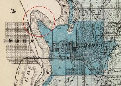
This caused all sorts of confusion as to who the land belonged to. Nebraska claimed it belonged to them and that it was now a part of Omaha City even though the city hadn’t officially annexed any of the land in the area. The area was even referred to as Omaha Island for a period of time. The issue wasn’t settled for good until the United Supreme Court ruled 15 years later in 1892 that it legally belonged to Iowa.
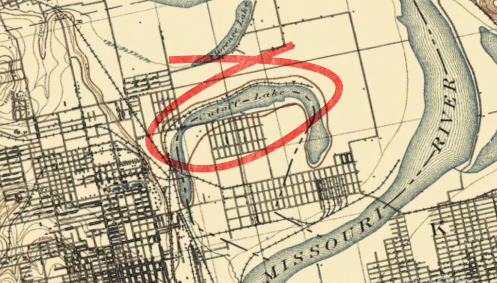
During that 15 year time frame, the new lake which went by different names including Cut-off Lake, East Omaha Lake, Lake Nakoma and finally Carter Lake became a hot spot. Already a popular place for fishing and boating, it became even more so with the opening of Courtland Beach in 1889. Referred to as “Omaha’s finest resort” it grew into Omaha’s first amusement park and had the area’s first roller coaster and Ferris wheel in addition to other amenities including a carousel, miniature railroad, boardwalk, dancing pavilion and beaches.

In the 1880’s as the South Omaha stockyards were being established, a group of investors saw potential in this area and thought it could become just as vital to Omaha City. To that end they formed the East Omaha Land Company and bought 2,000 acres of land. They immediately went to work to make it attractive to buyers. They platted it, graded the streets, installed water lines and sewers, installed street lights and street car lines. Its grand plan was to make the area into Omaha’s manufacturing center with the creation of the East Omaha Factory District in an area just east of Omaha Island.

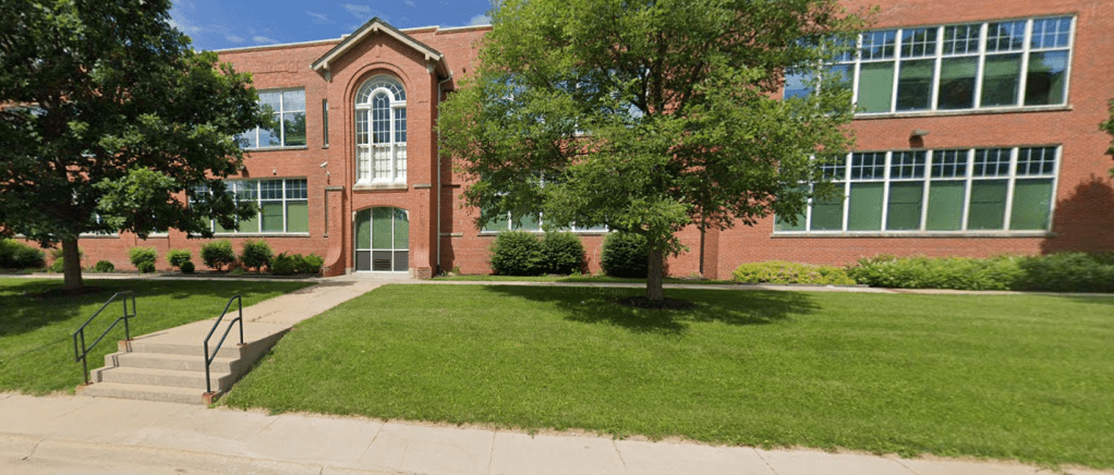
To assist in this effort the land company began building small homes nearby for the factory workers. Essentially a company town, it had dozens of houses ready to go by the time the businesses began building large industrial factories. The nearby Beechwood School had been established a few years earlier and was later joined by Sherman School which was there to help educate the children of the area’s workforce.

Businesses in the area included Barber Asphalt Paving Company, Adamant Wall Plaster, Omaha Cereal Company, Omaha Wagon Works and Monitor Hard Plastics. Other companies included the East Omaha Box Company and Marks’ Brothers Saddlery Company. Business was good and the district grew exponentially. It was during the 1890s that area first began being referred to as East Omaha.

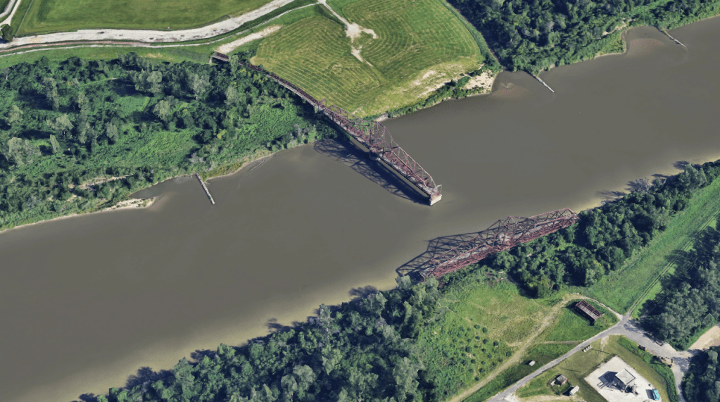
The streetcar line which ran from the factory district to the workers houses also ran across the Missouri River after the land company built the East Omaha Bridge in 1893. While Nebraska ultimately lost Courtland Beach to Iowa as a result of the court ruling a year earlier, it still had the thriving factory district. That was until the Panic of 1897 and floods in 1897 and 1899 stopped large scale business investment in the area. The area was now deemed too risky as Nebraska hadn’t yet installed a levee system along the river.

In its attempts to bring the area back to life, the East Omaha Bridge which ended up stuck as a result of the constant flooding was rebuilt and in 1908 became the largest double-swing bridge in the world. By 1917, however, it became evident that the lofty plans for a large factory district wouldn’t be realized. At that point hundreds of lots were sold “to the man of moderate means” for residential and farm development.

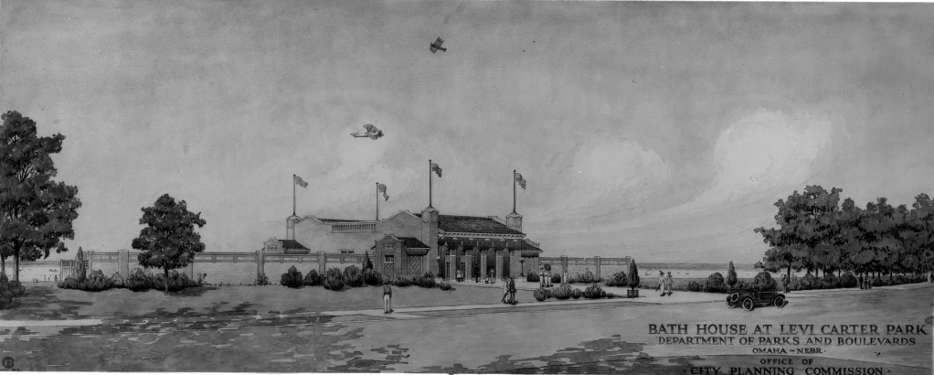
On the Iowa side, Courtland Beach, having closed and reopened, never returned to its previous level of popularity and was sold to the Omaha Rod and Gun Club as well as its subsidiary the Carter Lake Yacht Club. Across the lake on the Omaha side, Selena Carter Cornish donated land that belonged to her late husband, Levi Carter, to the city for use as a park. While not the same as Courtland Beach, the area became a popular destination in its own right with the establishment of Municipal Beach.
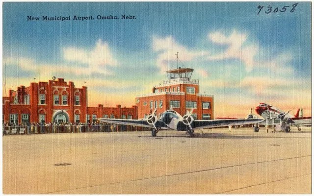
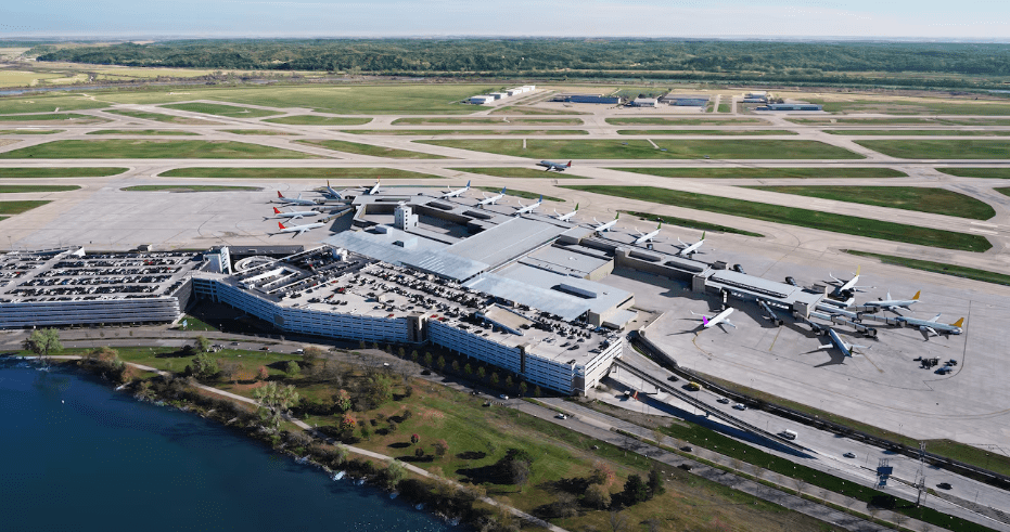
The opening of an airport wasn’t the intent of Omaha when it acquired 200 acres of land east of Carter Lake. The plan was to actually expand the size of the park but that changed when pilots began using the clear patch of ground to land their places. By 1925 the Omaha Municipal Airport was established. It didn’t get the name we love to hate – Eppley Airfield – until the 1950s.
The population of the small rural community grew from 100 in 1917 to more than 1,000 in 1930. Around this time a third school was opened in the area that catered to the rural kids of farmers whose formal education typically stopped by the eighth grade. The Pershing School was in its own school district.

Meanwhile the part of Council Bluffs that found itself on the Nebraska were frustrated by the lack of services and utilities that their neighbors on the proper side of the river received. By 1926 they successfully seceded from Council Bluffs and attempted to become a part of Omaha. Not wanting to absorb the cost of extending water and sewer lines, Omaha declined the offer (it would become the incorporated town of Carter Lake, Iowa four years later). Omaha’s refusal was not altogether surprising as it failed to keep up the streets, sidewalks and street lights for the Nebraska residents of the area. In fact, the only areas that were annexed by Omaha at this time were the park and the airport.

The area of East Omaha remained a patchwork of factories, residential communities, small farms, an illegal dump, salvage yards, businesses including auto wrecking and nightclubs like Chez Paree which operated an illegal gambling operation. Increasingly targeted by the police, the club suspiciously caught on fire and was destroyed in 1942 only to reopen on the Iowa side of the lake one day later.
The area was impacted by flooding yet again in 1947 which destroyed many houses in the area. That resulted in many of its residents relocating and the enrollment at Beechwood School suffered. It merged with Omaha Public Schools (OPS) and closed. Its remaining students were sent to nearby Sherman Elementary.
While Omaha finally installed a levee system along the river, residents in the community were often forgotten about and largely left to fend for themselves. It didn’t help that many of the remaining residents were poor and few had an education beyond the eight grade. The Pershing School merged with OPS in the 1950s after its residents voted to lower taxes making it impossible to fund it. The school at the south end of Eppley’s runway that had planes fly directly overhead and required landing lights on its roof ended up being demolished for airport expansion.
Following the lead of Carter Lake decades earlier, residents in the area even attempted to become its own incorporated town called Airport City. After that failed, the 2,800 residents in the area successfully petitioned the City of Omaha to annex it in 1957. Even so, it still remained largely forgotten as a third of the homes had no sewer access and another ten percent had no plumbing. The fact that nearly two thirds were owner occupied, however, made it an easy target for demolition in the name of airport expansion.

Today most of the land is owned by the city and is used for Eppley Airfield or the businesses that support it including car rental companies, parking lots and a hotel. The area is also home to the Open Door Mission, Omaha Correctional Center, Homeland Security and Freedom Park. The only traces to its past are the Omaha Box Company building that was constructed in 1890 and was recently renovated and the East Omaha Bridge which was built in 1893 and sits unused in its familiar spot along the Missouri River.
Please feel free to comment to share your thoughts and memories.
Until next time, keep exploring!
More pictures


Omaha Exploration is sponsored by

Click here to contact me if you’re interested in sponsoring OE.
Get email notifications when new OE content is posted
Follow OE on the socials
Omaha Exploration, 2024. Unauthorized use and/or duplication of this material without express and written permission from this site’s author and/or owner is strictly prohibited. Excerpts and links can be used, if full and clear credit is given to Omaha Exploration with appropriate and specific direction to the original content.

Leave a comment